Digital Experience
GROWhere
A map-based tool for exploring planting sites and finding local NGOs in India.
- My contribution
- Research, interface design and development with my professor.
- The output
- A website combining location data with local NGO contacts.
- Category
- Digital Experience
- Year
- Summer 2026
- Duration
- 3 weeks
- Made with
- Figma, React, Satellite Data, GIS, Python
- Live
- Open the site (opens in a new tab)
Where it sat
- Research — yes
- Concept — yes
- Product Design — yes
- Branding — no
- Development — yes
- MVP — yes
What came out
- Research — yes
- UX/UI — yes
- Design System — no
- Prototype — yes
- Website — no
- Application — yes
Who it was for
- Productivity — no
- Education — no
- Community — yes
- Brand Experience — no
- Creative Expression — no
- Social Impact — yes
Overview
About the project
I built GROWhere with a professor to help people explore planting sites in India. We started by reviewing Restor, then spoke with people interested in planting trees. The project grew to include local NGO contacts for people who wanted to contribute but could not visit a site.
The challenge
The problem
People we spoke to were worried about planting on land that belonged to someone else. A location could look suitable on a map and still be private property or farmland. We wanted to help users check the site and find someone nearby who could assist.
Design decisions
Helping people plant trees in India
My professor and I started by reviewing Restor. We wanted to focus on planting in India, where the people we spoke to were unsure which land they could use. We also needed a route for people who wanted to help but could not visit a site.
Starting with Restor
We saw room for a tool focused on the questions people face when planting in India.
Unclear land ownership
People we spoke to were concerned about planting on someone else’s property.
Finding time to help
Some people could support a planting effort but could not travel to the site themselves.
What needs checking
before planting here?
What the tool needed to help with
- 01
Is planting permitted?
Identify who owns the land and whether they allow planting.
- 02
Is the site suitable?
Check soil and land-cover information for the location.
- 03
Who can act locally?
Find an NGO nearby that the user can contact.
Two ways to participate
This route helps someone look into a site before visiting.
Source & context
Research inputs: our review of Restor and informal conversations with people interested in planting trees. This diagram explains our approach. Land ownership and permission still need to be checked locally.
The approach
What I did
We combined satellite imagery, soil moisture, land cover and zoning information in a map interface. Users could explore a location and contact local NGOs to discuss planting there. Ownership and permission still need local confirmation. I worked on the research, interface and development with my professor.
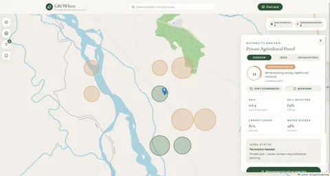
The work.
Select an image to view it full size.
Open Secret